DX Portfolio
Data Visualization for the Underrepresented Narrative
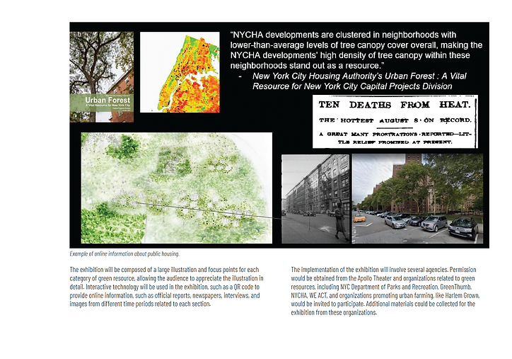
In Studio II of the Historic Preservation program, our group focused on developing context-oriented approaches that situate preservation research within a broader socio-environmental framework. Utilizing ArcGIS technology and the public database NYC Open Data, we mapped the distribution of street trees and open spaces in Harlem, a community predominantly composed of Black and Latin American residents in New York City. This analysis revealed the uneven distribution of green resources, contributing to discussions around social justice issues. To raise awareness of this underrepresented narrative, we selected specific locations related to green resources, such as community parks, public housing, and the iconic "Tree of Hope. We proposed an exhibition that featured visualizations of this data through paintings, making the information more accessible and engaging for the public.
TEAMMATES
Kemuning Adiputri, Elaf Alsibyani, Jacqueline Danielyan
INSTRUCTOR
Professor Bilge Korse, Professor Erica Avrami, Professor Morgan O'Hara
DURATION
Feburary 2022 - April 2022
AFFILIATION
Columbia University
CATEGORY
Data Visualization, Exhibition Design
DELIVERABLE
Geodata Mapping, Exhibition Proposal
MY WORK
Data Visualization, Illustration
TOOLS
ArcGIS, U.S. Geological Survey Database, Photoshop
DATA VISUALIZATION & ANALYSIS
-
Changes of Green Space from 1995 to 2015


In 2007, the Parks Department, in collaboration with a private organization, launched the Million Trees NYC initiative to plant new trees across the city. In 1995, the number of street trees in Harlem was significantly lower compared to the Upper West Side and Upper East Side of Manhattan. By 2015, when the initiative concluded, the number of street trees in Central Harlem had increased. However, certain areas in East Harlem still lacked adequate street tree coverage, suggesting possible government oversight.
-
Different Types of Trees in Harlem in 2015

The Parks Department oversees all trees in publicly owned spaces, such as street trees and park trees. Meanwhile, NYCHA, as the second-largest owner of open spaces, provides green resources in areas where street trees are lacking. Since the 1950s, trees have been planted around public housing developments, making NYCHA trees a vital green resource in neighborhoods with limited open spaces. In East Harlem, NYCHA appears to serve as the predominant "provider" of trees.